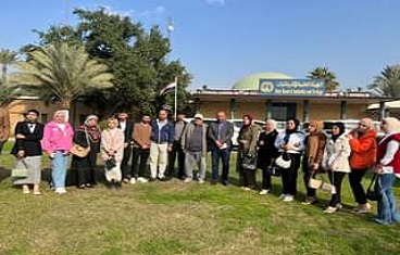
A number of students of the Department of Remote Sensing and Geographic Information Systems at the College of Science, University of Baghdad, have conducted a scientific field visit to the Department of Archaeological Investigation at the General Authority for Antiquities and Heritage in the company of the department’s teachers. The visit aimed to see the use of GIS science in the Department of Investigations and Excavations through what was reviewed by those concerned in the department about the uses of this science to detect archaeological sites and follow up on abuses in an accurate scientific manner, as well as to identify the weekly cultural activities of the authority in its sciences and exchange information and scientific and research experiences related to them.
The scientific visit included the delegation put forward an initiative to survey archaeological sites by students of the Department of Remote Sensing and under the supervision of their teachers in cooperation with the staff of the department organized by a joint cooperation contract and pure Iraqi staff, which is closely related to the students’ specialization of (map production) and the computer laboratory for GIS, as the students learned about the devices used and the old and modern scientific methods taken to explain the curriculum for each laboratory because of its common specialized topics related to some vocabulary of the subjects, which motivates them to reach successfully For some experiences that contribute to the development and expansion of their acquired information, access to similar disciplines, and the acquisition of the spirit of scientific and knowledge cooperation with other disciplines, to promote useful information for the public interest and community service.