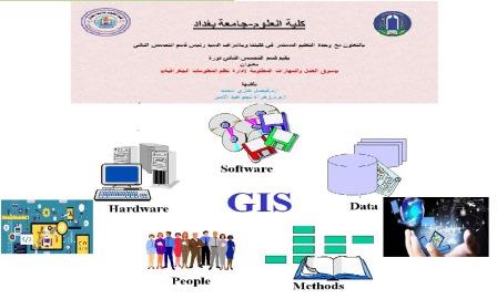
The Department of Remote Sensitivity and Geographic Information Systems in collaboration with the Continuing Education Unit at the Faculty of Science has organized a virtual course entitled “The labor market and the skills required to manage GIS” with the participation of a number of teachers and those concerned with specialization, qualification and employment. The aim of the course was to introduce the required skills and a job market to specialize in remote sensitivity, especially the ability and knowledge of computers, dealing with programs, the basics of programming and willingness to learn them, the use of GIS tools and the good ability to use one of the available GIS programs, knowledge of the system of geographical coordinates, production of maps and the ability to read them, and knowledge of how to raise data and turn it into formulas that can be dealt with in specialized programs.
The course that was presented by Prof. Dr. Faisal Ghazi Mohammed and Assist. Prof. Dr. Zahra Nahm Abdul Amir included identifying the requirements of the labor market for remote sensitivity specialists, analyst capabilities, good knowledge in geographical concepts and spatial sciences in general, good ability to use available tools and employ them appropriately in the field of review, exploration, analysis, forecasting and data analysts’ functions in the centers of studies, research and strategic centers to support decision-making and in academic research and the importance of using tools. Statistics and handling of big data, as well as the specialization of mapping, processing and conversion of aerial and space images, space engineering or what is known as geomatics and all related procedures required to create a series of spatial data and some geographic information system (GIS) programs that can be handled also and how to conduct field surveys, collect data, equip their database with analyses and to make related decisions.